|
Deckers Creek |
one moment while we fetch a trail picture
|
|
|
Deckers Creek |
one moment while we fetch a trail picture
|
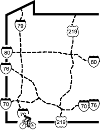
Vicinity: Directions begin headed south on I79 at the West Virginia rest area near the PA/WV state line. To get here from Pittsburgh, take I79 south.
Morgantown trailhead: From the West Virginia rest area follow I-79 south for about 3.3 miles. Take exit 155 for Star City and West Virginia University. At the bottom of the ramp, turn left/east following the signs for “to 7”. Go 0.4 miles, and at the tee turn right/east onto Route 7 East. Follow Route 7 for about 3.5 miles. Where US19 turns right/west across the river, and SR7 turns left/east continue on US119 South for about 200 feet. At the bus garage turn right, towards the river and go 100 feet to the trailhead parking. This lot is also the trailhead parking for the Gasper Caperton Trails. Start your trip from here. As you face the river, go to your left about 300 feet and then turn left to follow the Decker Creek Trail rather than crossing the bridge over Deckers Creek.
Marrilla Recreation Center trailhead: From the West Virginia rest area follow I-79 south for about 3.3 miles. Take exit 155 toward West Virginia University. At the bottom of the ramp, turn left/east following the signs for “to 7”. Go 0.4 miles, and at the tee turn right/east onto Route 7 East. Follow Route 7. Go about 1.4 miles and watch for Old Decker’s Creek Rd to fork to the right. The trail crosses just after this turn. Park nearby.
Vicinity: Directions begin where SR7 passes under I-68. To get here from Pittsburgh, take I79 south. From the West Virginia rest area just across the PA/WV state line, follow I-79 south for about 3.3 miles. Take exit 155 toward West Virginia University. At the bottom of the ramp, turn left/east following the signs for “to 7”. Go 0.4 miles, and at the tee turn right/east onto Route 7 East. Follow Route 7 as it twists and turns (not easy). In about 3 miles you will pass under I-68.
Mellon’s Chapel trailhead: This trailhead parking is not available on Sundays from 9Am to noon, and on Wednesdays from 6 PM to 9PM. After passing under I-68, continue for about 2.0 miles. Just after passing the sign for Dellslow, follow the trail signs by taking the sharp right turn around the tavern/bar. Continue up hill, first a left hand fork, then a right hand fork, always taking the steepest way up hill. About 0.4 miles up the hill there is Mellon Chapel on your left. Turn left into the church’s parking area between the cemetery and the trail.
Masontown trailhead: After passing under I-68, continue for about 9.3 miles to Masontown. At the near edge of town take the sharp u-turn to the right/west onto Bridgeway Ave. Go about 0.2 miles and you should see the trail on your right. Take the right/west turn onto Sand Plant Rd. GO 200 feet and park in the trailhead parking lot on your right.
Reedsville trailhead: After passing under I-68, continue for about 12.8 miles to Reedsville. Turn right/south onto SR 92. Go 0.4 miles. Just after crossing the trail, turn right/west into the trailhead parking lot.
Deckers Creek - Access Points
Vicinity: Directions begin headed south on I79 at the West Virginia rest area near the PA/WV state line. To get here from Pittsburgh, take I79 south.
Morgantown trailhead: From the West Virginia rest area follow I-79 south for about 3.3 miles. Take exit 155 for Star City and West Virginia University. At the bottom of the ramp, turn left/east following the signs for “to 7”. Go 0.4 miles, and at the tee turn right/east onto Route 7 East. Follow Route 7 for about 3.5 miles. Where US19 turns right/west across the river, and SR7 turns left/east continue on US119 South for about 200 feet. At the bus garage turn right, towards the river and go 100 feet to the trailhead parking. This lot is also the trailhead parking for the Gasper Caperton Trails. Start your trip from here. As you face the river, go to your left about 300 feet and then turn left to follow the Decker Creek Trail rather than crossing the bridge over Deckers Creek.
Marrilla Recreation Center trailhead: From the West Virginia rest area follow I-79 south for about 3.3 miles. Take exit 155 toward West Virginia University. At the bottom of the ramp, turn left/east following the signs for “to 7”. Go 0.4 miles, and at the tee turn right/east onto Route 7 East. Follow Route 7. Go about 1.4 miles and watch for Old Decker’s Creek Rd to fork to the right. The trail crosses just after this turn. Park nearby.
Vicinity: Directions begin where SR7 passes under I-68. To get here from Pittsburgh, take I79 south. From the West Virginia rest area just across the PA/WV state line, follow I-79 south for about 3.3 miles. Take exit 155 toward West Virginia University. At the bottom of the ramp, turn left/east following the signs for “to 7”. Go 0.4 miles, and at the tee turn right/east onto Route 7 East. Follow Route 7 as it twists and turns (not easy). In about 3 miles you will pass under I-68.
Mellon’s Chapel trailhead: This trailhead parking is not available on Sundays from 9Am to noon, and on Wednesdays from 6 PM to 9PM. After passing under I-68, continue for about 2.0 miles. Just after passing the sign for Dellslow, follow the trail signs by taking the sharp right turn around the tavern/bar. Continue up hill, first a left hand fork, then a right hand fork, always taking the steepest way up hill. About 0.4 miles up the hill there is Mellon Chapel on your left. Turn left into the church’s parking area between the cemetery and the trail.
Masontown trailhead: After passing under I-68, continue for about 9.3 miles to Masontown. At the near edge of town take the sharp u-turn to the right/west onto Bridgeway Ave. Go about 0.2 miles and you should see the trail on your right. Take the right/west turn onto Sand Plant Rd. GO 200 feet and park in the trailhead parking lot on your right.
Reedsville trailhead: After passing under I-68, continue for about 12.8 miles to Reedsville. Turn right/south onto SR 92. Go 0.4 miles. Just after crossing the trail, turn right/west into the trailhead parking lot.